
Kenya's land market moves fast. Agents call with urgency. Developers show glossy brochures. Prices rise in areas near new roads and infrastructure. And buyers, caught up in the momentum, often sign before they have properly answered the most important question of all: do I actually know what I am buying?
Land fraud, boundary disputes and undisclosed encumbrances cost Kenyan buyers billions of shillings every year. But a large portion of these losses are not from deliberate fraud. They come from buyers making decisions without enough verified spatial information. A title deed tells you who owns a parcel on paper. It does not tell you where the boundaries actually are on the ground, what the terrain is like, whether the access road floods in the long rains, or whether a neighbouring development has already encroached.
The data to answer all of these questions exists. The gap is in bringing it together quickly and clearly before a purchase decision is made.
The five things most buyers skip
1. Boundary verification on the ground
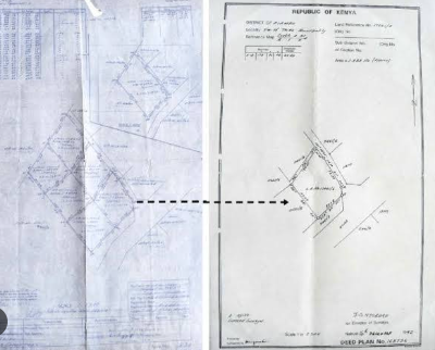
A title deed references a survey number and a mutation. Those documents show boundaries as lines on paper. What they do not show is whether those boundaries match what is physically on the ground. Fences, walls, structures and cultivation can all sit outside the legally registered boundary. In areas with historical subdivision disputes — common in peri-urban Nairobi, Kiambu, and parts of the Rift Valley — the discrepancy can be significant.
Before any purchase, a licensed surveyor should confirm that the beacons are in place, undisturbed and consistent with the survey plan. If beacons are missing or displaced, the boundary needs to be re-established before transfer.
2. Title search and encumbrance check
A title search at the relevant land registry reveals whether the title is genuine, who the registered owner is, and whether there are any charges, caveats, cautions or court orders registered against it. This search costs very little and takes a day. Skipping it to save time is one of the most expensive shortcuts a buyer can take.
The introduction of Ardhisasa — Kenya's national land information management system — has made title searches more accessible than ever. But the system still has gaps, particularly for older titles and parcels in counties still migrating records to the digital platform. A physical registry search remains important in many areas.
Watch for this: A seller who is reluctant to allow a title search or who insists on a very short due diligence window is a red flag. Genuine sellers with clean titles have nothing to hide and every reason to make verification easy.
3. Terrain, drainage and flood risk
Kenya's rainfall patterns and topography mean that land which looks perfectly habitable in the dry season can be unusable — or even dangerous — during the long or short rains. Low-lying areas near rivers, seasonal drainage channels and natural depressions are particularly vulnerable.
Flood risk is assessable from satellite-derived elevation data and rainfall analysis without ever visiting the site in the wet season. A terrain model can show you slope direction and drainage accumulation. A multi-year satellite time series can show you whether land has historically experienced flooding. This analysis takes hours, not weeks, and can prevent catastrophic purchase mistakes.
4. Access and infrastructure
An access road that appears on a map may not be maintained, may be privately owned, or may require crossing a third party's land. Distance to a tarmac road matters enormously for both usability and resale value. In areas like Konza, Syokimau or the outskirts of Nakuru, the difference between a plot 200 metres from tarmac and one 2 kilometres away can represent 40% of value.
Infrastructure proximity — electricity connection distance, water supply source, mobile network coverage, proximity to schools and health facilities — all feed into the long-term usability and value of a parcel. These are all spatially measurable before you commit.
5. Soil type and construction suitability
Not all land is equally buildable. Black cotton soil — common in parts of Nairobi, the Rift Valley floor and lowland areas — expands when wet and contracts when dry, creating serious foundation challenges for construction. Red loam, laterite and sandy soils each have different bearing capacities and drainage characteristics. Knowing the soil type before purchase affects your engineering costs, your construction timeline and your insurance options.
The data to make a confident land purchase decision already exists for almost every parcel in Kenya. The question is whether anyone has brought it together for you before you sign.
The due diligence checklist
Before you sign — verify these
- Title deed authenticity and ownership history via registry search and Ardhisasa Confirms the title is genuine and the seller is the registered owner
- Physical boundary verification with a licensed surveyor Confirms beacons are present, undisturbed and consistent with the survey plan
- Encumbrance check — charges, caveats and cautions Reveals any debts, court orders or third-party claims registered against the title
- Flood risk and terrain assessment using satellite elevation data Shows drainage patterns, low-lying areas and historical inundation risk
- Soil type and construction suitability check Identifies black cotton soil zones, bearing capacity indicators and drainage suitability
- Road access quality and connectivity analysis Measures distance to tarmac, confirms access road status and ownership
- Infrastructure proximity — electricity, water, network coverage Quantifies connection costs and confirms service availability
- Land use zoning and planning status confirmation Confirms permitted uses and any development restrictions in the county spatial plan
What we are building to solve this
At Geocode Spatial Solutions Ltd, we are developing a Land Intelligence Platform that brings all of this information together into a single report for any parcel in Kenya. Instead of commissioning eight separate checks from eight different sources, a buyer receives one comprehensive spatial intelligence report covering all of the above — with a computed land suitability score and a clear recommendation.
The platform is being built initially for land selling companies to embed into their buyer-facing websites, so that any prospective buyer can access verified spatial intelligence for a plot before they visit or commit. We believe this is how the Kenyan land market should work — and we are building the infrastructure to make it possible.
The cost of getting it right versus the cost of getting it wrong
A comprehensive land due diligence engagement typically costs a fraction of one percent of the purchase price. For a KSh 2 million plot, a thorough due diligence report including boundary verification, title search, spatial risk assessment and infrastructure analysis might cost KSh 15,000 to 30,000 and take three to five business days.
Compare that to the cost of discovering post-purchase that your title has an encumbrance, your boundary is disputed, your land floods for three months every year, or your access road belongs to a neighbour who decides to close it. Land litigation in Kenya is slow, expensive and emotionally draining. Prevention is not just cheaper — it is transformative.
Need a land due diligence report before you buy?
We carry out comprehensive spatial due diligence for land buyers across Kenya. Boundary verification, title checks, flood risk, soil assessment and infrastructure proximity in one report.
Request a report